Implications for Delivery
A movement and place model recognises that there are different priorities across our network according to the needs of different road users and the purpose that we have for each section of road. The challenge then is to make sure that we have designed our movement and place model with a recognition of how the conditions we have described will manage energy to levels that are within those that are tolerable by humans in a crash, preventing deaths and serious injuries.
This has a range of clear implications for how we develop and deliver a movement and place model:
We must recognise that roads must have different functions and design accordingly
Roads cannot simultaneously accommodate both a high flow and high place function
Road users will operate best where the function and expectations are clear
We must ensure that the model prescribes speeds that align with tolerable levels in case of conflict
Background
Movement and place models are used by transport planners to describe roads according to their purpose(s), which is often a mixture of mobility (movement) and social (place) functions. From a safe and healthy mobility perspective, the function (or purpose) of roads includes what traffic they need to support (both motorised and non-motorised) and how that traffic needs to be able to move safely. This can be about movement of people and goods from place to place but can also relate to broader social functions, such as children moving freely around their neighbourhood, places where people can exercise, opportunities to shop, chat and enjoy local amenities. This has long been understood in the Scottish context where designing streets for Scotland talks about how “Streets exert an immense influence upon our lifestyles and behaviour. Street design also has a direct influence on significant issues such as climate change, public health, social justice, inclusivity and local and district economies.”
A movement and place model can improve road safety because it clearly defines the intended purpose of each road type within our network and creates expectations around the speed and safety of movement, the sense of place and quality of the environment. By categorising roads, we can design and manage them to match their function - whether that’s facilitating high-speed, long-distance travel or providing safe access to homes and businesses. If done correctly, this alignment between road function and design should ensure that speed limits, lane widths, segregation, signage, and pedestrian/cyclist provisions are appropriate for how the road is used, managing potential conflict so that crashes cannot cause unacceptable levels of harm.
What the Research Shows
Movement and place models build on the understanding that we will perform at our best when we design environments in ways that reflect human limitations, both perceptual (reducing complexity and allowing time for decision making) and physical (managing conflicts so that they are survivable).
Typical movement and place models are presented as a matrix that shows the movement function of roads on one axis and the place function on the other axis, as shown in the example below from Transport for London. Each box of the matrix then describes the type of road features, speed limits and access restrictions that will allow this road to function safely and effectively for its identified purpose.
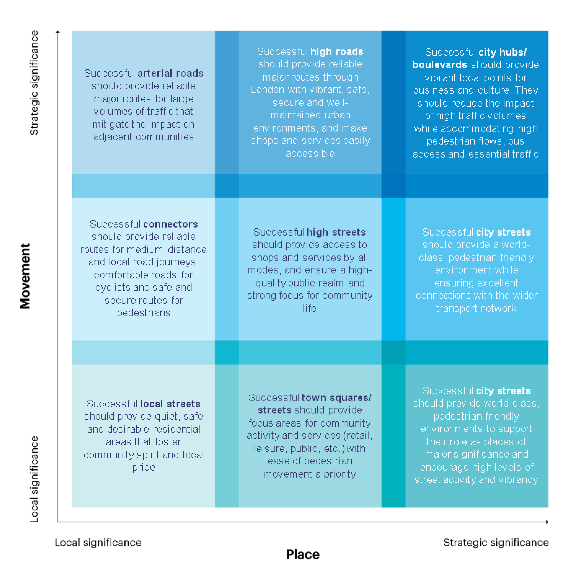
London’s Street Family Classification (TfL)
Movement and place models establish the principle that network safety is compromised when a high place function (where people live, play, work and dwell) exists alongside a high movement function (where efficient movement is required for transit); bringing people into conflict with motorised or non-motorised traffic that creates heightened levels of risk.
With a clear classification system, road authorities can better implement speed management, enforcement priorities, and infrastructure investments, ultimately creating a safer, more predictable, and more forgiving road environment for all users.
From a safety perspective, a clear classification system supports consistent expectations for road users, which is crucial for minimising conflict. For example, drivers expect limited access and higher speeds on motorways, while they anticipate pedestrians, cyclists, and frequent turning movements on local roads. Mixing these functions (like having high-speed traffic on roads serving schools or homes) leads to increased crash risk.
More recently, efforts have been made to provide clear direction on the levels of speed which will be tolerable across a movement and place model. From a Safe System perspective, this will likely mean that we end up with some blank space in the top right of our movement and place model because roads which are required to carry high volumes of traffic at speed, will not be compatible with a high density of place which mixes large numbers of vulnerable road users.
This means that we might end up with a model that looks more like the one below:
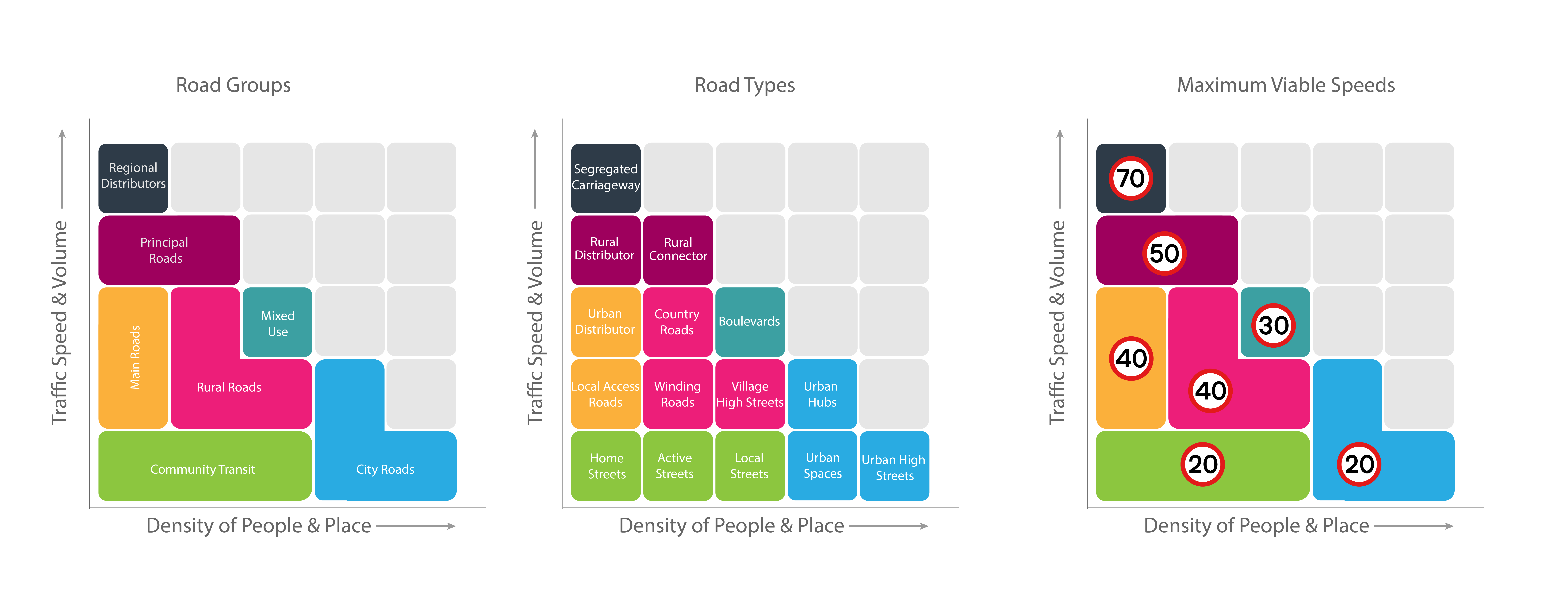
Functional Hierarchy Model
The value of a movement and place model like this is that it does give greater clarity on the speed management expectations required to maintain a safe environment, especially for non-motorised traffic.
Sources
Truong, J., Strandroth, J., Logan, D. B., Job, R. F. S., & Newstead, S. (2022). Utilising Human Crash Tolerance to Design an Interim and Ultimate Safe System for Road Safety. Sustainability, 14(6), 3491. https://doi.org/10.3390/su14063491
Williams, M., Breen, J., Campsall, D., Charman, S., Cuerden, R., Davies, D., Reed, N., Simpson, S., (2021) Safe Roads for All. Brake, London, UK. https://www.saferoadsforall.org/
TfL Roads Task Force (2013) RTF Report 2013. https://tfl.gov.uk/corporate/publications-and-reports/roads-task-force